
“And it’s so clear, you can see the bottom from 10 meters up.”
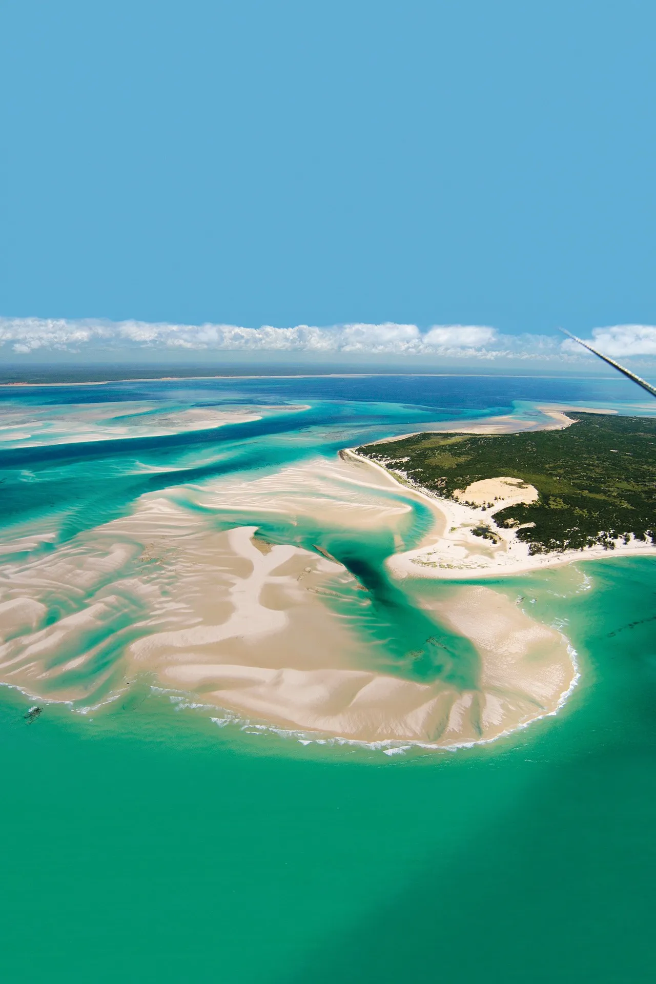
There is a stretch of the Indian Ocean, roughly 25 kilometers off the coast of central Mozambique, where the water does something that defies every instinct you have about the sea. It doesn’t look like water. It looks like glass; tinted the faintest shade of aquamarine and stretched flat over pale sand. Water clarity here reaches up to 30 meters. From a helicopter, from the bow of a dhow, from a low pass in a light aircraft, you look straight through the ocean and watch the ripples on the floor move in slow motion below you.
This is the Bazaruto Archipelago, Mozambique. And almost everything ever written about it stops right there; at the spectacle of the view without asking the one question that actually matters:
Why is the water this clear? Buckle up. Because the answer is wilder than the view.
It Starts With Rivers. Or Rather, the Absence of Them

Most coastal waters are murky for one simple reason: rivers. Rivers drag sediment, agricultural runoff, topsoil, and dissolved organic matter into the sea, staining it brown and green for miles offshore. Rivers flowing into the Indian Ocean deposit more suspended sediment than those draining into any other major ocean, with nearly half of it coming from the Indian subcontinent alone. The world’s famously turbid coastlines; the Bay of Bengal, the Amazon delta, the mouth of the Ganges; are murky precisely because of this relentless continental bleeding into the sea.
Bazaruto sits in a gap. The five islands of the archipelago; Bazaruto, Benguerra, Magaruque, Bangue, and Santa Carolina; lie off the Inhambane Province coast, positioned in a section of the Mozambique Channel that is almost uniquely insulated from major river discharge. The Zambezi, one of Africa’s great sediment carriers, empties far to the north. The coastal hinterland is relatively low-runoff, semi-arid savanna. The result is an offshore marine environment that receives almost none of the terrestrial sediment load that clouds so much of Africa’s eastern shore.
What you get, then, is a rare oceanographic stillness. Warm, shallow, sediment-poor water over a white sand and coral substrate. The light reflects off the sand in a way that makes even deeper sections feel illuminated from below; the sort of clarity that encourages long, lazy dives.
The clarity is not magic. It is geography.
The War That Accidentally Saved a Paradise
Here is the part of this story that travel writing almost never tells: Bazaruto is pristine, partly because Mozambique was at war.
Mozambique gained independence from Portugal in 1975. Two years later, a brutal civil war erupted that lasted until 1992. During the colonial era, a luxury hotel in Santa Carolina had catered to the world’s elite, in a locale dubbed “Paradise Island”; an era when Mozambican beaches were glamour destinations, enshrined in popular culture in songs like Bob Dylan’s “Mozambique.” That all fell apart as independence gained strength, and the ruins of the Santa Carolina hotel sit today as a reminder of that myopic time.

But the collapse of tourism infrastructure set off an unintended chain reaction. Bazaruto was gazetted as a national park in 1971, making it Mozambique’s first protected area. It was one of the few conservation successes to survive the civil war largely intact; partly because the islands’ isolation limited access.
While the rest of the world’s tropical coastlines were being discovered, developed, and depleted through the 1970s and 1980s, Bazaruto was effectively unreachable. No mass tourism. No hotel construction booms. No industrial fishing fleets. The reef systems that took thousands of years to build were left to build in peace. The seagrass meadows that filter the water and anchor the entire ecosystem were not dredged, not trawled, not poisoned.
Bazaruto’s extraordinary water clarity today is, in part, a gift from historical catastrophe.
The Creature That Proves It
If you want a biological certificate of water quality, look no further than the dugong.
In the clear, shallow waters of the Bazaruto Archipelago, a quiet, slow-moving marine mammal grazes across seagrass meadows; a species many people have never seen in the wild, and one that could soon disappear without urgent conservation action. The dugong is now listed as Critically Endangered on the IUCN Red List in the Western Indian Ocean.

Here is what stops most people cold when they learn it: the Bazaruto dugong population; estimated at between 250 and 350 individuals, is the only known, fairly large dugong population within the entire Western Indian Ocean. From Kenya to Tanzania, from the coast of Somalia to the shores of the Arabian Peninsula, the dugong has been locally driven to extinction. Only here, in this one clear, shallow, seagrass-carpeted bay, does a viable herd survive.
Dugongs eat seagrass. Seagrass requires clear, well-lit, shallow water to photosynthesize. Where seagrass thrives, water is clean. Where water is clean, dugongs live. It is a closed biological loop and Bazaruto is the last place on this side of the planet where that loop is still running.
The Bazaruto Archipelago is not only a tropical holiday paradise. It is a UN-recognized marine and coastal ecosystem of global significance, covering more than 1,400 square kilometers and protecting vibrant coral reefs and thriving seagrass meadows crucial to ocean health.
The clarity of the water is not a visual amenity. It is the life-support system of the last herd of its kind on Earth.
What NASA Sees When It Looks Down
The archipelago’s five islands lie up to 20 kilometers from the Mozambican mainland. When tides are at their lowest, sand flats extending a kilometer or more from shore become temporarily exposed, with a tidal range generally between 2 and 4 meters.

When the Landsat 9 satellite captured imagery of the archipelago in 2024, what it photographed was essentially what divers see from below: a luminous, shallow bay where the ocean floor is visible through the water column as clearly as a tile through an empty swimming pool. The color gradients; bright white at the sandbars, turquoise in the shallows, deep cobalt at the reef edges, are not photo-edited. They are the optical signature of extraordinarily clear, sand-floored water with almost nothing in it to scatter the light.
Seen from space, Bazaruto looks less like a coastline and more like a painting of one.
Timing It Right; Because Not Every Month Is Equal
Here is something the Instagram posts won’t tell you: clarity and marine life are not always on the same schedule.

Cooler months often correlate with improved visibility, while warmer months may bring increased plankton, occasionally reducing clarity but supporting higher biological productivity. The window of peak transparency runs from September through October, bringing the best combination of water clarity, calm seas, and marine life encounters; including the humpback whale migration that passes through Bazaruto’s deep channels between July and October.
When plankton blooms, visibility drops; but whale sharks follow the plankton. When clarity peaks, the reefs reveal their full architectural complexity. Choosing when to visit Bazaruto is really a question of what kind of transparency you’re after: the “visual” kind, or the “biological” kind.
Both are extraordinary. They just peak at different months.
The Deeper Transparency
There is something almost philosophical about a place where the sea hides nothing.
Most of the ocean is a world of concealment; dark, pressured, impenetrable. But at Bazaruto, the water has no secrets. What is there is visible. What has been protected is legible. The seagrass meadows wave slowly below a boat ten meters down, lit from above like a sunlit field. The last dugongs on this coast graze among them in plain sight from the air.

Bazaruto’s isolation and protection have guarded one of the world’s last populations of dugongs; the giant underwater grazers on the verge of extinction. The reef systems, the fish populations, the migratory whale routes; all of it persists because the water stayed clear. And the water stayed clear because the seagrass and the reefs were never destroyed. It is a loop. A rare, fragile, still-running loop.
The beach was always there. The water was always this clear.
It just took a civil war, a collapsed colonial hotel, and 50 years of inadvertent protection for the world to look down from ten meters up and finally see it.
The Bazaruto Archipelago is a marine national park in Inhambane Province, Mozambique. Best visited between May and October. Access via Vilanculos, with boat or helicopter transfers to the islands. Visibility peaks September–October.